

Magnolia Hollow Conservation Area – Panoramic Mississippi River Views from Limestone Bluffs
Ten miles north of Ste. Genevieve on Magnolia Hollow Road, the rugged 1,740-acre Magnolia Hollow Conservation Area rises above the Mississippi River—a recreation and outdoor lover’s paradise where steep bluffs provide panoramic views of the river bottomlands, Establishment Creek winds through dense hardwood forests, and bald eagles soar past limestone cliffs in winter months. This Missouri Department of Conservation property offers accessible overlooks, forested hiking trails, primitive camping, and the kind of wild, minimally managed landscape that protects sensitive watersheds while inviting nature enthusiasts to experience the dramatic terrain defining Ste. Genevieve County’s Mississippi River borderlands.
The Panoramic Overlook: Why People Come to Magnolia Hollow
Most visitors arrive for one reason: the view.
The Accessible Viewing Platform:
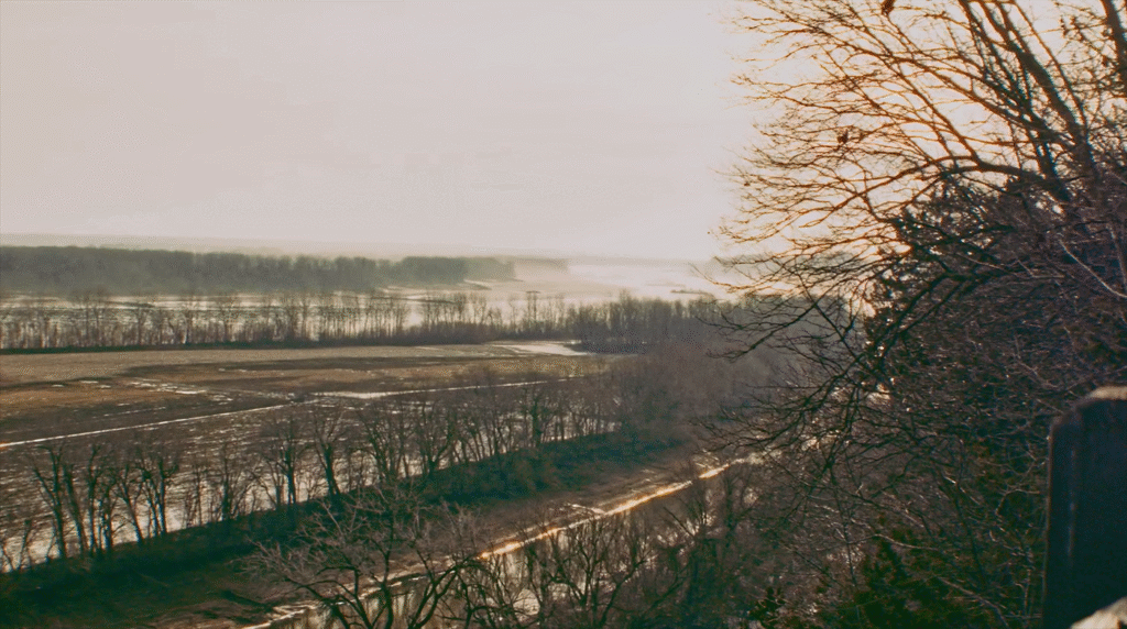
A short paved trail (approximately 1/8 mile from the parking lot) leads to a wooden viewing platform with guardrails and benches—designed for wheelchair accessibility and safe viewing for all ages and abilities.
From the platform, elevated on limestone bluffs hundreds of feet above the floodplain, you see:
The Mississippi River – Visible in the distance, the great river that shaped French colonial settlement patterns, served as superhighway for fur traders and merchants, created the fertile bottomlands attracting habitants from Kaskaskia, and remains North America’s defining waterway
River bottomlands – The floodplain below, where dense forest conceals Establishment Creek and wetland habitats—a patchwork of green extending toward the river channel
Schmidt’s Island – Wooded island in the Mississippi River floodplain, alternately flooded and exposed depending on river levels, visible from the overlook
Illinois shore – Across the Mississippi, the eastern bank where the French colonial villages of Kaskaskia, Prairie du Rocher, and Fort de Chartres once dominated Upper Louisiana before Ste. Genevieve became the first permanent European settlement west of the river
Sky and clouds – Unobstructed views of weather systems moving along the river valley, sunset colors reflected in the Mississippi, and in winter, bald eagles riding thermals above the bluffs
The overlook platform includes benches where visitors can sit quietly, absorbing the scale of the Mississippi River valley that humans have inhabited for millennia but never truly controlled.
Winter Eagle Watching:
Bald eagles are commonly sighted along the Mississippi River at Magnolia Hollow during winter months (November through March). Eagles migrate to the region seeking open water and abundant fish, roosting in large trees along the river and hunting from perches overlooking channels. Bring binoculars and scan the riverside trees—you might spot eagles’ distinctive white heads against dark branches, or watch them soar past the bluffs with seven-foot wingspans riding river valley wind currents.
The 1.2-Mile Loop Trail: Descending Into the Hollow
For hikers wanting more than the overlook platform, Magnolia Hollow offers a 1.2-mile loop trail (approximately 30-60 minutes) descending from the bluffs into the forested hollow, following Establishment Creek drainage, and climbing back to the parking area.
The Trail Experience:
The trail begins at the viewing platform (where paved accessible path ends) and heads into the woods, immediately transitioning from manicured overlook to rugged forest path.
Descending the bluffs – The trail winds down the steep limestone slopes through mixed hardwood forest (northern red oak, hickory, ash, walnut), losing elevation as you leave the overlook heights. The descent can be steep in sections—reviewers recommend trekking poles for stability, especially when trail conditions are muddy or leaf-covered.
Creek bottom – Near the lowest point, the trail approaches Establishment Creek drainage—a wet-weather creek bottom where water flows during rainy periods but may be dry during drought. Here the forest feels different: cooler, damper, more enclosed. A short spur trail heads toward Establishment Creek itself (the permanent stream forming Magnolia Hollow’s northern boundary).
Navigation challenge – Trail marking can be inconsistent, particularly near the creek bottom where multiple paths and game trails confuse the route. Keep eyes open for trail markers and natural “stairs” (rock steps) indicating the main path. Some hikers report difficulty finding where the trail climbs back up the hillside—if you reach the creek bottom and lose the path, look for a small bridge and natural rock steps ascending to the right.
Climbing back – The return ascent is steep initially, then moderates as the trail switchbacks up the hollow walls. This section provides workout—you’re climbing from the creek drainage back to the bluff-top parking elevation.
Return to overlook – The loop reconnects with the paved accessible trail near the viewing platform, completing the circuit.
Trail Conditions and Cautions:
Reviewers note the trail can be overgrown during summer months, with limited maintenance compared to heavily trafficked state park trails. Expect:
- Spider webs across the path (indicating low traffic)
- Leaf cover obscuring the trail surface in autumn
- Muddy sections after rain
- Poison ivy along the trail edges
- Steep rocky sections requiring careful footing
This is conservation area hiking, not manicured park trail—part of the appeal for those who prefer wilder, less crowded outdoor experiences.
The Conservation Area: 1,740 Acres of Rugged River Borderland
Magnolia Hollow Conservation Area, managed by Missouri Department of Conservation, preserves rugged Mississippi River bluff country bordered by Establishment Creek (northern boundary) and Schmidt’s Island.
The Landscape:
This is not gentle rolling farmland or easy river bottomland—Magnolia Hollow features:
Steep bluffs – Limestone cliffs carved by millions of years of Mississippi River erosion and Establishment Creek watershed drainage, rising sharply from the floodplain
Dense mixed hardwood forests – Northern red oak, hickory, ash, walnut, and other species adapted to thin limestone soils and rocky slopes; 1,653.2 acres of forest and woodland
Cedar glades – Open rocky areas where eastern red cedar grows among wildflowers, grasses, and drought-tolerant plants
Old fields – Former agricultural clearings (75 acres) reverting to forest and savanna, providing edge habitat for wildlife
Savanna – 12 acres of open woodland with grassy understory
Deep hollows – Steep-sided draws like Magnolia Hollow itself, where cooler microclimates support ferns and moisture-loving plants
Brickey Hills Natural Area:
Within the conservation area, Brickey Hills Natural Area (designated natural area status) preserves exemplary river bluff forest—hardy timber species that root in limestone fractures, withstand exposure to wind and ice, and create the signature Mississippi River borderland forest defining this landscape.
Establishment Creek and Sensitive Watershed Management:
Establishment Creek, a permanent stream, flows along Magnolia Hollow’s northern boundary before emptying into the Mississippi River. Tributaries including Indian Creek and Fourche a Du Clos drain steep forested watersheds where erosion control is critical.
Management of Magnolia Hollow and Establishment Creek corridors is minimal and designed to protect the steep and sensitive watersheds. The Missouri Department of Conservation prioritizes:
- Watershed health over recreational development
- Natural processes over intensive vegetation manipulation
- Low-impact public access over extensive trail systems
- Habitat protection for native species
This management philosophy means fewer amenities, fewer trails, and more wilderness character compared to intensively developed state parks—appealing to visitors who value solitude and minimal human impact.
Wildlife:
The conservation area supports:
- White-tailed deer – Abundant throughout the forests
- Wild turkey – Woodland game bird thriving in hardwood forests
- Cottontail rabbit – Found in old fields and forest edges
- Bald eagles – Winter residents along the Mississippi River
- Songbirds – Over 25 warbler species documented during migration, plus year-round forest birds
- Reptiles and amphibians – Snakes, turtles, salamanders, and frogs in various habitats
Birdwatchers consider Magnolia Hollow under-birded despite its diverse habitat mix (woodland, riparian, grassland, lake), offering opportunity for those willing to explore beyond the main overlook.
Additional Recreation Opportunities
Beyond hiking and wildlife watching, Magnolia Hollow Conservation Area offers:
Primitive Camping: Dispersed primitive camping is permitted year-round at designated sites—no facilities, no water, no electric hookups. Campers must be self-sufficient with their own equipment, water, and waste disposal. Camping provides opportunity to experience dawn and dusk when wildlife activity peaks, to watch stars unobscured by light pollution, and to hear the forest at night.
Hunting: The conservation area provides good woodland game hunting including deer and turkey, following Missouri Department of Conservation regulations and seasons. Hunters appreciate the rugged terrain and relatively low hunting pressure compared to more accessible properties.
Shooting Ranges:
- Skeet/shotgun range – Clay pigeon target shooting
- Archery range – Static archery targets for practice
These facilities serve the regional shooting sports community and hunters preparing for seasons.
Fishing: Establishment Creek and Mississippi River access provide fishing opportunities, though access to the river itself can be challenging depending on water levels and terrain.
Bicycling: Bicycles are permitted on roads open to vehicular traffic and service roads (per Missouri Department of Conservation regulations). Groups of 10+ cyclists require special use permit.
The Tour de Lime: Cycling Route to Magnolia Hollow
For road cycling enthusiasts, Magnolia Hollow serves as the northern terminus of the Tour de Lime—a challenging 27.46-mile route from downtown Ste. Genevieve featured on Cycle Ste. Gen (cyclestegen.com).
The Route:
Starting from downtown Ste. Genevieve (America’s oldest permanent European settlement west of the Mississippi), the Tour de Lime follows public roads north through 27.46 miles of Ste. Genevieve County, accumulating 1,978 feet of elevation gain as it climbs from river valley to upland ridges and back down toward the Mississippi River bluffs.
Important: This is road cycling on public roads shared with vehicle traffic. Cyclists must watch for cars, especially on narrower county roads where shoulders disappear and sightlines curve through wooded hills. The route demands attention, fitness, and bike-handling skills commensurate with nearly 2,000 feet of climbing spread across 27+ miles.
Why Magnolia Hollow as Terminus?
The Tour de Lime deliberately ends at Magnolia Hollow Conservation Area rather than looping back to downtown because the conservation area offers the perfect reward for the ride:
Earned views – After 27+ miles and 2,000 feet of climbing, reaching the Magnolia Hollow overlook provides psychological payoff: dramatic Mississippi River views from limestone bluffs rising hundreds of feet above the floodplain
Post-ride hiking – The short paved accessible trail to the viewing platform is perfect for stretching cycling-weary legs; ambitious riders can tackle the 1.2-mile loop trail for more exploration
Natural contrast – Transitioning from hours on asphalt watching for cars to walking quiet forest trails creates mental and physical shift—same landscape, different pace, new perspectives
Recovery facilities – Parking, pit toilets, picnic table, shade, and scenic overlook benches provide space to rest, hydrate, refuel, and prepare for the return ride (many cyclists arrange vehicle support or shuttle service for pickup rather than repeating the 27-mile route)
Eagle watching bonus – Winter rides might reward cyclists with bald eagle sightings
The Tour de Lime Name:
The route references Ste. Genevieve’s limestone heritage—the quarries and kilns that industrialized the region in the late 19th and early 20th centuries, producing lime for mortar and plaster that built St. Louis and other Midwest cities. As you pedal north from downtown’s French colonial core through countryside shaped by 290 years of European settlement, you’re riding through landscape where limestone bluffs formed 500 million years ago, where French habitants farmed the Grand Champ bottomlands, where German immigrants established villages, where lead miners dug ore, and where modern vineyards now thrive.
Cycle Ste. Gen:
The Tour de Lime is one of several curated routes on Cycle Ste. Gen (cyclestegen.com), a community resource connecting road, gravel, and mountain bike enthusiasts in the Ste. Genevieve area. The website features:
- Downloadable GPS routes with elevation profiles
- Strava group for tracking rides and connecting with local cyclists
- Information on events like The Missouri Outlaw Gravel Race (formerly Trailnet’s StG Gravel Classic, held annually in April)
- Updates on group rides and cycling resources
For cyclists, the Tour de Lime transforms Magnolia Hollow from drive-to nature destination into earned experience—you pedal there, not just park there.
Lewis and Clark Connection
Magnolia Hollow Conservation Area preserves forested highlands similar to those William Clark observed during the Corps of Discovery’s passage in December 1804.
After camping south of Ste. Genevieve, Clark and the expedition passed the mouth of Gabouri Creek on December 4, 1804—the landing place for Ste. Genevieve’s trading boats. Continuing upriver, Clark noted “the high lands juts to the river and form a most tremendous Clift of rocks.”
The “tremendous clift of rocks” Clark described would have been the limestone bluffs in this area—steep riverside cliffs rising dramatically from the floodplain, covered in dense hardwood forest, visible from the river as major landmarks. Magnolia Hollow’s overlook offers the opposite perspective: looking down from those bluffs toward the river channel where Lewis and Clark’s keelboat and pirogues passed 220+ years ago.
Practical Information
Name: Magnolia Hollow Conservation Area
Address: Magnolia Hollow Drive (dead-ends at conservation area), Ste. Genevieve, MO 63670
Size: 1,740 acres (1,653.2 acres forest/woodland, 75 acres old field, 12 acres savanna)
Managing Agency: Missouri Department of Conservation Phone: (573) 290-5730
Hours: Open daily 4:00 AM – 10:00 PM
Admission: Free
Directions from Ste. Genevieve:
- Take Highway 61 North
- Turn right (east) on Route V
- Go 1 mile on Route V
- Turn left (north) on Magnolia Hollow Road
- Continue until road dead-ends at conservation area parking lot
Important Navigation Note: If approaching from the south via Interstate 55, do NOT follow Google Maps routing via Industrial River Road and White Sands Road—there is no access from that direction. Instead:
- Take I-55 North to Exit 154
- Highway 61 North to Highway V
- Proceed as described above
Access Issues: When the Chester river gauge reaches 35 feet, the area becomes difficult to access due to flooding.
Facilities:
- Parking lot
- Accessible pit toilets
- Paved accessible trail to viewing platform (approx. 1/8 mile)
- Viewing platform with benches and guardrails
- One picnic table near overlook
- 1.2-mile loop hiking trail
- Primitive camping area (no facilities)
- Skeet/shotgun range
- Archery range
No facilities: No water, no electric, no shelters, no restrooms beyond pit toilets
Trail Difficulty:
- Paved overlook trail: Easy, wheelchair accessible
- 1.2-mile loop: Moderate (steep sections, uneven terrain, some navigation challenges, recommend trekking poles)
Best Times to Visit:
Winter (November-March): Eagle watching season; clearer views from overlook after leaves fall; cooler temperatures for hiking; potential ice on steep trail sections
Spring (April-May): Wildflowers blooming; trees leafing out; comfortable temperatures; wetter trail conditions; increased tick activity
Summer (June-August): Full forest canopy; hot and humid; trail may be overgrown; good for early morning or evening visits
Fall (September-October): Fall foliage colors; comfortable temperatures; leaf cover on trail surface; pleasant hiking weather
What to Bring:
- Water (no water available on-site)
- Snacks/lunch for picnicking at overlook
- Binoculars for eagle watching and distant river views
- Trekking poles for loop trail navigation
- Tick repellent and tick checks after hiking
- Trail map or GPS (trail marking can be inconsistent)
- Camera for overlook views
- Layers (bluff-top can be windy)
Pets: Dogs allowed, must be leashed due to deep woods and cliffs
Ratings:
- Tripadvisor: 4.0/5 stars, ranked #17 of 23 things to do in Sainte Genevieve
- AllTrails: Reviews highlight nice overlooks and Mississippi River views; challenges include poor maintenance and muddy areas
Building Magnolia Hollow Into Your Ste. Genevieve Itinerary
Magnolia Hollow pairs naturally with several visit types:
Half-Day Nature Escape: Morning or afternoon visit (2-3 hours): overlook viewing, 1.2-mile loop hike, picnic lunch, eagle watching in winter
Cycling Adventure: Full-day Tour de Lime ride from downtown (plan 4-6 hours depending on fitness level, plus time at conservation area)
Photography Expedition: Sunrise or sunset at overlook for dramatic river valley light; winter visits for eagle photography; fall colors
Multi-Day Outdoor Itinerary: Combine with other Ste. Genevieve County conservation areas and trails:
- Hawn State Park (30 minutes south) – Pickle Springs Natural Area shut-ins, Whispering Pines Trail
- Hickory Canyons Natural Area – Lamotte sandstone box canyons with wet-weather waterfalls
- Felix Valle State Historic Site – Historic downtown Ste. Genevieve attractions
- Route du Vin wineries – Scenic vineyard visits between outdoor adventures
Lewis and Clark Trail: Magnolia Hollow connects to broader Lewis and Clark National Historic Trail interpretation—combine with downtown Ste. Genevieve historic sites where Corps of Discovery camped
Where Bluffs Meet River, Where Cyclists Meet Hikers
Magnolia Hollow Conservation Area proves that Missouri’s oldest town offers more than French colonial architecture and wine country roads—it preserves wild river borderlands where limestone bluffs carved by ancient oceans rise above North America’s defining waterway, where bald eagles hunt from riverside perches, where sensitive watersheds flow undisturbed toward the Mississippi, and where visitors willing to drive ten miles north and hike steep trails discover panoramic views earning their place on any Ste. Genevieve bucket list.
Walk the accessible paved trail to the overlook platform. Scan the river bottomlands for eagles. Descend the loop trail into the forested hollow. Or arrive by bicycle after 27 miles of earned climbing, then celebrate with a hike overlooking the Mississippi.
At Magnolia Hollow Conservation Area—where the Tour de Lime meets the river bluffs, where 1,740 rugged acres protect what Lewis and Clark called “tremendous clift of rocks,” where minimal management preserves maximum wilderness.
Sorry, no records were found. Please adjust your search criteria and try again.
Sorry, unable to load the Maps API.